 vesseltracker.com
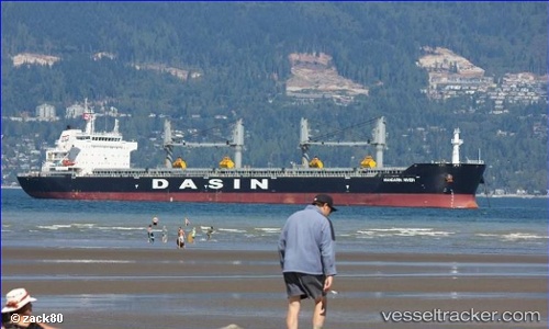
Vessel MANDARIN RIVER IMO: 9533335, MMSI: 636019610 Bulk Carrier
Live AIS position:
UTC. Near Marmagao),
updated 2025-10-17 20:48:25 UTC.
Find the position of the vessel MANDARIN RIVER on the map. The latter are known coordinates and path.
marine traffic ship tracker show on live map
The current position of vessel MANDARIN RIVER is 15.44335 lat / 73.72057 lng. Updated: 2025-10-17 20:48:25 UTCCurrently sailing under the flag of Liberia
MANDARIN RIVER built in 2011 year
Deadweight:
56774 tDetails:
Last coordinates of the vessel:
2025-10-17 20:48:25 UTC, 15.44335, 73.72057, course: 118, speed: 0.1